Past Races
2012
The Course
Click to expand map view. Download the Wilderness Traverse race package for complete compeitior insturctions, maps and more
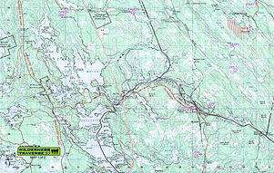

Event Director Bob Miller has revealed the 2012 Wilderness Traverse race course and, as promised, it will provide competitors with physical and navigational challenges as they travel through some of Muskoka’s wildest areas.
Racers will board buses at the Bala Community Centre and ride to the north end of Nine Mile Lake Road near Torrance. At 8 a.m. they will run 2 km down the road to Nine Mile Lake carrying their paddling gear. When they reach the lake, they’ll choose canoes and set off on a 25-30 km paddle through a series of quiet lakes and down the Gibson River, heading roughly west. They will visit CPs on Brotherson’s Lake and at a hunt camp beside the Gibson River. This canoe route is seldom used, and some of the portages are quite rough, rocky and overgrown. Teams with canoe tripping experience will have an advantage.
After 5-7 hours of paddling, racers will drop their canoes beside the ball diamond on the south shore of Gibson Lake and head back southeast for a 25-30 km trek through a remote and beautiful area of lakes and rocky ridges. They will first return on foot to the hunt camp CP along the Gibson River, then head out on a 10 km trek to another hunt camp on Lower Boleau Lake. There are few trails to help them in this area; they’ll need to watch the terrain and their maps, compasses and watches closely as they bushwhack.
Most teams will swim from the hunt camp to the opposite shore and continue southwest for several kilometers to a CP on a pond near the north bank of the Severn River, then they’ll head into Severn Falls on ATV trails, finishing with a short swim across the river under the railroad bridge. This trek will take teams 5-10 hours and may well be the decisive leg that separates the group of lead teams from the rest. Less experienced teams who finish this trek in the dark are unlikely to make the cut-off to stay on the full course.
Racers will transition to bikes and head south, west and then north for 35-40 km on snowmobile trails, ATV trails and quiet roads and along a powerline. Recent heavy rains may have made these rocky trails muddy and created some large puddles. Most teams will ride some or all of this section in the dark, adding to the challenge. They will come out onto South Gibson Lake Rd. and revisit the checkpoint/TA at the ball diamond on their way to the bike/trek TA further west. Teams reaching the ball diamond after 1 a.m. will move to the short course, returning to the snowmobile trail system on their bikes to ride north to Ragged Rapids on the Musquash River.
Teams continuing on the full course will head a short distance west on roads to a bike/trek transition area just east of Highway 400 on the Gibson River. The full ride is expected to take 3-5 hours. Racers will head under the highway bridge and head north toward Go Home Lake. They’ll visit a CP on the south shore of Miner’s Bay near Potter’s Landing, then swim across and continue north near the eastern shore of Go Home Lake. They’ll travel along rocky ridges and through open forest, swimming or wading when they reach several minor water crossings. Teams will be here in the dark and must use good lights and be cautious of their footing, as the terrain can be irregular, steep or muddy.
Teams will reach a CP at Flat Rock Rapids where volunteers will be available to help ferry racers to the north side of the water using canoes. Teams will be permitted to swim if they feel comfortable and stay well above the rapids. From Flat Rock, teams will roughly follow a powerline until they hit the cottage road that winds around Galla Lake. From there, they’ll have a 3 km run to the public boat launch on the north side of the lake. This 20-25 km trek is expected to take teams 5-10 hours.
Racers will get back on their bikes and head east for a final 20-25 km bike ride. They will start on quiet roads, then turn onto a snowmobile trail that travels through Wahta Mohawk territory. They will emerge onto a gravel road and ride to the dam at Ragged Rapids. This ride is expected to take 2-4 hours.
Teams will drop their bikes here and get into canoes for a final 6 km paddle east toward the Bala public boat launch. This will take about an hour, then it is a short run to the finish line at the Bala Community Centre and a much needed nap!
Race Reports
Smells like Team Spirit
Shed Coffee Bar/NHRace.com
Untamed Torpedoes
TRL
Beowulf
Bugs in Teeth
Bugs in Teeth
Mountain Goats
Salomon Suunto
Untamed Torpedoes
Salomon Suunto
Bugs in Teeth
Salomon Suunto
Beowulf
Beowulf
Kinetic Konnection
Smells Like Team Spirit
Media
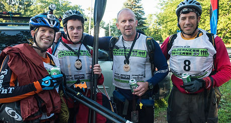
Gallery Photos on this page by Luis Moreira
Check out addtional photos in the Flickr Photostream or the Wilderness Traverse Facebook Page


Part 1
Part 2
Video by Active Steve of
Part 3